Your Shopping Cart is empty.
Earthquake in Dimapur, Nagaland
Keywords
Earthquake Dimapur NagalandFile Details
Published: 05/18/2021 Rating: Category: General Viewed: 1341 Downloads: 0
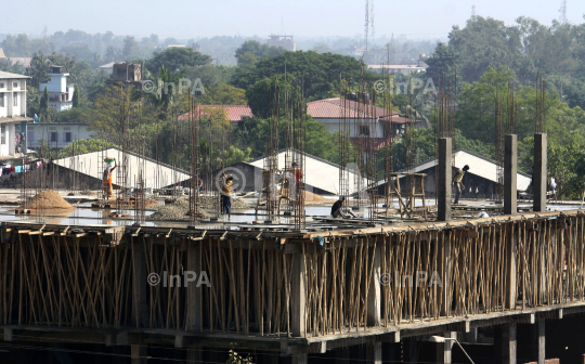
Indian daily wages labor works on a construction building after an earthquake in Dimapur, India’s north eastern state of Nagaland on Monday, November 21, 2011. An earthquake measuring 5.9 on the Richter scale rocked India’s northeast state and Myanmar in the morning with epic centre located in Mynamar, 137 km (85 miles) South East of Kohima, Nagaland, according to US Geological Survey website. In September, more than 50 people died after a killer quake measuring 6.8 on the Richter scale shook the region. The Indian north eastern state of Assam, Meghalaya, Mizoram, Tripura, Nagaland, Arunachal Pradesh and Manipur - are considered to be the sixth most earthquake-prone belt in the world by seismologists. Photo by Caisii Mao/Indian Photo Agency (InPA)
Indian daily wages labor works on a construction building after an earthquake in Dimapur, India’s north eastern state of Nagaland on Monday, November 21, 2011. An earthquake measuring 5.9 on the Richter scale rocked India’s northeast state and Myanmar in the morning with epic centre located in Mynamar, 137 km (85 miles) South East of Kohima, Nagaland, according to US Geological Survey website. In September, more than 50 people died after a killer quake measuring 6.8 on the Richter scale shook the region. The Indian north eastern state of Assam, Meghalaya, Mizoram, Tripura, Nagaland, Arunachal Pradesh and Manipur - are considered to be the sixth most earthquake-prone belt in the world by seismologists. Photo by Caisii Mao/Indian Photo Agency (InPA)
